Locations on Mars
Interesting and Easy to Identify Locations
Locations on this page have been chosen based on being both interesting and easy to identify.
Past evidence of water, caves, lava flows, and other features are covered in this page.
Mars Topographical Map
Tharsis Montes, Valles Marineris, Chryse Planitia
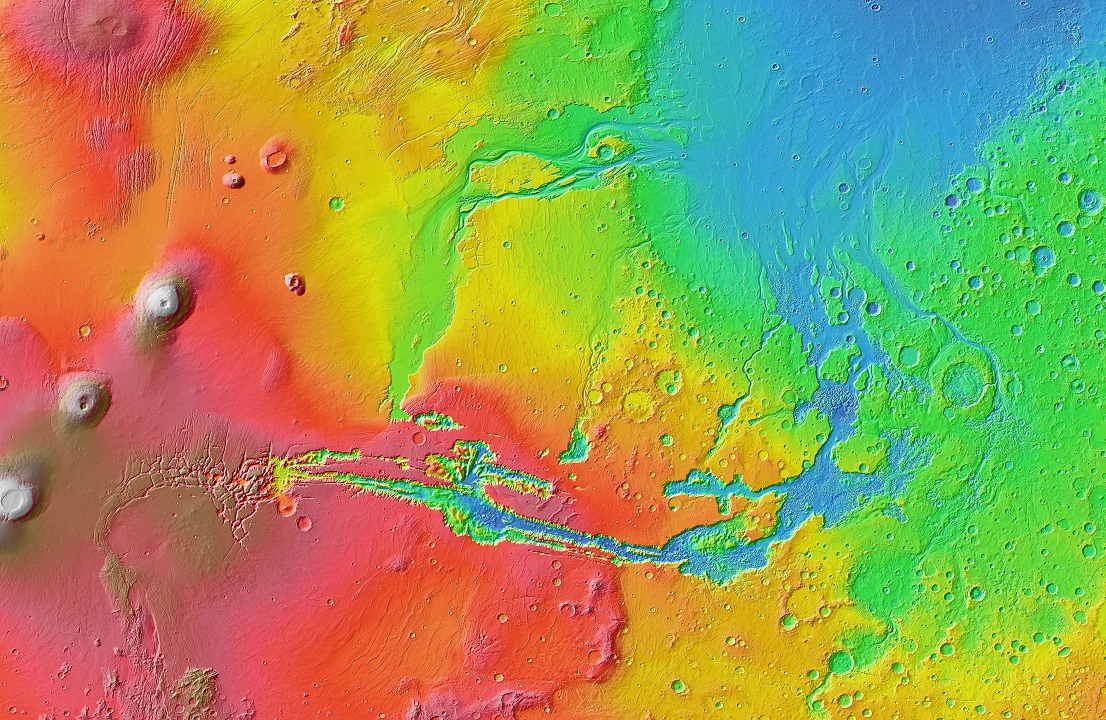
Tharsis Montes, Arsia Mons, Valles Marineris, Chryse Planitia are visible in the image.
Image credit: Courtesy NASA / JPL-Caltech / Arizona State University
Locations
In the left of the image, Tharsis Montes is visible as a line of 3 large volcanoes
(circular and white in appearance on the map),
visually moving eastwards (to the right),
Noctis Labyrinthus
with its shattered appearance, further east
the
large canyon of
Valles Marineris
extends eastwards, and finally northwards, until it ends at
Chryse Planitia,
the ocean-like blue region in the top right of the image.
Many river-like outflow channels * are visible (having a blue in colour in the image), ending in Chryse Planitia.
* Outflow channels are long wide channels on Mars. They are thought to have been carved out by liquid water during huge rare episodic floods, although some authors believe they may have been formed by glaciers, lava, or debris flow.
Examples: notable outflow channels near the Chryse region include:
Kasei Vallis, Maja Valles, Shalbatana Vallis, Simud Valles, Tiu Valles, and Ares Vallis.
Low number of impact craters per area: There is a low number of visible impact craters in some places,
which is an indication that the terrain is newer and
many impact craters that previously would have been present,
have been eroded or covered by some mechanism.
This can be especially seen inside Chrysa Planitia,
compared to the terrain surrounding it especially in the East.
There is also a relatively low number of impact craters in the area
surrounding the 3 volcanoes and southwards, suggesting that lava flows (likely from the volcanoes)
have recently covered this surface
(seen especially in the red area in the above image). Notice also how the red area signifies it is higher
than the surrounding terrain yet relatively flat, as might be expected if lava flowed over a surface.
See also:
MAP Of Mars - Mars Topographical Map (Wikipedia)
with location names.
3D View - NASA Mars 3D View which can be used to explore Mars' surface.
Instructions for 3D View - Using NASA Mars 3D View (Quick Instructions on this page).
Valles Marineris

(Cropped version of the original image)
Image centered on the large canyon Valles Marineris which ends in Chryse Planitia. (Note that the western part of Vallis Marineris called Noctis Labyrinthus is not fully shown in the image but can be seen in the image at the top of the page.)
Image credit: Courtesy NASA / JPL-Caltech / Arizona State University
Valles Marineris is a very large canyon on the surface of Mars, it is one of the largest canyons in the solar system, more than 4000 km (2500 mi) long, aproximately 200km (120 mi) wide and 7km (4.3 mi) deep.
Valles Marineris extends just eastwards from Tharsis Montes (the line of 3 large volcanoes - visible in the left of the top image on this page), and finally northwards, until it ends at Chryse Planitia, in the northern hemisphere.
Location:
Near the Equator. West.
East of Tharsis Montes (the line of 3 volcanoes in the Tharsis region).
Coordinates:
Lat Lng: 13.9° S 59.2° W
BASEMAP Coordinates: -59.2, -13.9
Chryse Planitia
Image credit: Courtesy NASA / JPL-Caltech / Arizona State University
Chryse Planitia, which in Greek means "golden plain", is a relatively smooth plain in the northern region of Mars.
It is the ocean-like (colored blue in the image) region visible in the top right corner of the above image.
Chryse Planitia is one of the lowest regions of Mars, being 2 to 3 kilometers (1.2 to 1.9 mi) below the mean surface level of Mars, so any flowing water from higher elevations would tend to run into it.
Diameter:
1600 km, 990 mi
The Viking 1 Lander landed in Chryse Planitia.
Chryse Planitia shows evidence of water erosion in the past.
On the southern edge,
Valles Marineris
ends in Chryse Planitia.
To the west, Kasei Valles and Maja Valles appear to run from high areas to
Chryse Planitia, and it's believed these channels carried water into Chryse Planitia in the past.
To the east, Areas Vallis ends in Chryse Planitia.
It's theorised that Chryse Planitia contained a large lake or ocean in the past, as all of the large outflow channels * entering it end at the same elevation.
Location:
Northern hemisphere. West.
East of Tharsis Montes (the line of 3 volcanoes in the Tharsis region).
Coordinates:
Lat Lng: 28.4 °N 319.7 °E
BASEMAP Coordinates: 319.7, 28.4
Arsia Mons
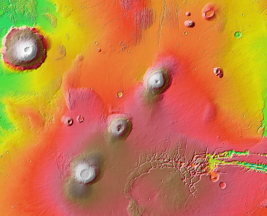
The line of three volcanoes make up Tharsis Montes, which is one of the most noticeable features on Mars.
Olympus Mons is visible as the large volcano in the top left of the image.
Arsia Mons is the southernmost volcano of Tharsis Montes (the volcano in the bottom of the image).
Image credit: Courtesy NASA / JPL-Caltech / Arizona State University
Arsia Mons is the southernmost volcano of the line of 3 volcanoes of Tharsis Montes. It is a shield volcano *, 435 kilometers (270 mi) in diameter, and more than 9 kilometers (5.6 mi) higher than the surrounding plains.
It is visible on the left edge of the above image, as the southern most volcano.
Diameter:
435 km, 270 mi
7 cave entrances on the flanks of Arsia Mons appear to be visible on satellite imagery. These are believed to have been formed by the collapse of lava tube ceilings.
Location:
Northern hemisphere. West.
Tharsis Montes (southernmost volcano).
Coordinates:
Lat Lng: 8.35 °S 120.09 °W
BASEMAP Coordinates: -120.09, -8.35
* Shield Volcanoes are volcanoes having a low profile, resembling a warrior's shield lying on the ground, formed by the repeated release of highly fluid (low viscosity) lava over a long time period, which produces the volcano's shield like shape.
Olympus Mons
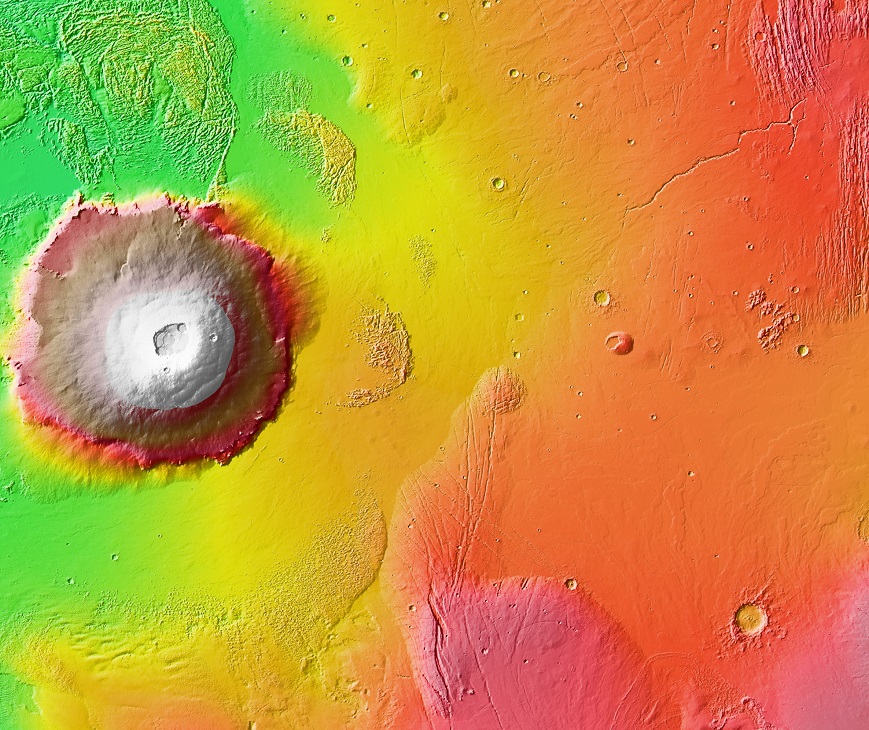
Image credit: Courtesy NASA / JPL-Caltech / Arizona State University
Olympus Mons is a large shield volcano *, and the tallest mountain on a planet.
Its peak is 25 km (16 mi) high above the local plains surrounding it, and is about 602 km (374 mi) in diameter (which is about the size of Arizona, USA). Its caldera is 80 km (50 mi) wide.
Diameter:
602 km, 374 mi
Location:
North hemisphere. West.
Northwest of Tharsis Montes (the line of 3 volcanoes in the Tharsis region).
Coordinates:
Lat Lng: 18.65° N 226.2° E
BASEMAP Coordinates:
226.2, 18.65
Isidis Planitia
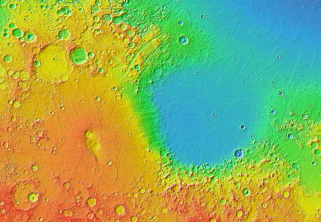
Image credit: Courtesy NASA / JPL-Caltech / Arizona State University
Isidis Planitia is large plain in the Northeast of Mars, and the third largest obvious impact structure on the planet.
Diameter:
1500 km, 930 mi
When exploring Mars using online tools, Isidis Planitia can be identified by size and its shape, and is approximately 1500 km (930 mi) in diameter.
The Mars Reconnaissance Orbiter (MRO) found magnesium carbonate around the Isidis impact basin, indicates that water was present and that it was not acidic, PH conditions that would have been more favorable for life.
On the north-western edge of Isidis Planitia is the Jezero crater, which the Perseverance Rover is currently exploring.
Location:
Northern hemisphere. East.
Coordinates:
Lat Lng: 12.9 °N 87.0 °E
BASEMAP Coordinates: 87.0, 12.9
Noctis Labyrinthus
Image credit: Courtesy NASA / JPL-Caltech / Arizona State University
Noctis Labyrinthus, (Latin for "labyrinth of night") is a system of deep steep walled valleys with chasmata *, grabens and crater chains that have a maze like appearance, part of the western region of Valles Marineris.
It is visible east of Arsia Mons (visible in the image above), with a shattered-like appearance.
Location:
Near the Equator. West.
East of Tharsis Montes.
* Chasma (singular), chasmata(plural), are deep, elongated, steep sided depressions. They are visible on Mars and many other planets and moons in the solar system.
Using the NASA 3D Tool
On arriving at the NASA Mars 3D View Eyes on the Solar System page:
- Press the [HD] button in the left hand panel - to enable you to clearly see the surface when you zoom in.
- Press the Lighting button on the right hand side of the screen (looks like a half illuminated circle), and select Flood Lighting - to enable you to see the whole surface, not just the day side.
- Zoom in with the mouse wheel or press the [+] and [-] buttons to zoom in.
- Drag the mouse on the planet to move or rotate the surface and look at different locations.
Note: Disabling the Layers for Spacecraft and Trails, will allow the page to operate faster. (The Layers icon is 2nd from the top on the right of the screen - then turn off spacecraft and trails options).
Like / Follow / Contact
If you found this page useful or interesting, please consider following us or liking us on Facebook. You are welcome to share the page further on social media or other related websites.
You can contact us using our Facebook page (or by email on our Contact us page), if you have feedback, suggestions or questions.
About us and this website
You can read more About us (and this website), including information about the online Space Related Tools available on this website. We appreciate your time and interest.
September, 2023: We are currently looking to do website development work or analysis work for additional clients. Please consider working with us if you like our work on this site, and have projects available, or would like features added or improvements made to your existing website. See our About us page for more information.
Sources of Information
The main sources of information on this page are from Wikipedia and NASA websites, which were then re-written and / or re-arranged by RL / JL (Xalyse.com). We are grateful to all the people involved in providing the valuable information in these sources.
Main Sources
https://en.wikipedia.org /wiki/Valles_Marineris
https://en.wikipedia.org /wiki/Chryse_Planitia
https://en.wikipedia.org/wiki /Arsia_Mons
https://en.wikipedia.org /wiki/Isidis_Planitia
https://mars.nasa.gov /gallery/atlas/olympus-mons.html
https://en.wikipedia.org /wiki/Olympus_Mons
https://en.wikipedia.org /wiki/Noctis_Labyrinthus
https://en.wikipedia.org /wiki/Outflow_channels
https://en.wikipedia.org /wiki/Chasma
The Moon - Current and Future Exploration
If you enjoyed reading this article you may also enjoy our article on
The Moon - Current and Future Exploration.